Vessel traffic management

Comprehensive traffic management tools for maritime authorities.

Talk to our experts

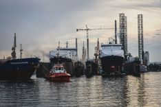
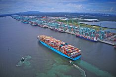
The Cybernetica Vessel Traffic Management Information System (VTMIS) enhances maritime security by improving navigation safety and efficiency. It provides maritime authorities with a comprehensive overview to monitor and manage vessel traffic, prevent incidents, protect lives at sea, and safeguard the marine environment.

Seamless integration

The modular design and open architecture of the Vessel Traffic Management Information System (VTMIS) enable the integration of various sensors tailored to specific locations and customer requirements. The system offers flexibility for customised installations.

Various use-cases

The Vessel Traffic Management and Information System (VTMIS) is used by maritime authorities and is adaptable for ports, VTS centres, and Ship Reporting Systems (SRS). It can also support MRCCs, border guard, and naval operations when integrated into Border & Coastal Surveillance Systems.

Secure, reliable and flexible

Built according to industry best practices, the Vessel Traffic Management Information System is secure, reliable, and flexible, fully complying with International Maritime Organization (IMO) and International Association of Marine Aids to Navigation and Lighthouse Authorities (IALA) regulations.

Vessel Traffic Management Information System core components

Sensorics

Wide variety of inputs are available from different sensors (RADAR, AIS, METEO, CAMERAS and more).

Control centre

Contains main system (VTS) servers and redundant servers, with any customer-relevant additional components.

Operator centre

Contains operator workstations, providing control of communications and functions.

Remote access workstations

A mobile, flexible, and hardware-agnostic solution accessible from any device (laptop, tablet, or mobile) with a browser and Internet connection. Can operate as a stand-alone or complement in-house operator positions, providing full system functionality including real-time traffic image and two-way audio.

Key features

Data processing & integration

Automatic collection, processing and integration of data from various sensors, including radars, Automatic Identification Systems (AIS), closed-circuit television (CCTV), radio direction finders (RDF), and a weather station.

Traffic image creation

Visualisation of vessels and their movements in the responsibility area. A consolidated display integrating radar, Automatic Identification System (AIS), and multi-sensor targets, along with historical trails, providing a comprehensive overview of all elements within a single system.

Automatic target identification

The system facilitates automated detection of vessels, thereby enhancing situational awareness and decision-making processes, enabling prompt responses to potential threats or anomalies.

Traffic management & planning

Managing traffic and the planning of vessel movements to prevent congestion and dangerous situations.

Route management

An additional feature for vessel traffic management designated to ensure safety and efficiency of vessels navigation.

Traffic and risk alerting

Provision of customisable real-time notifications and alerts to operators for managing vessel traffic, preventing collisions, and mitigating risks to ensure maritime safety.

Decision support tools

Different tools that support decision-making, including Closest Point of Approach (CPA ), Time to Closest Point of Approach (TCPA), and Estimated Relative Bearing Line (ERBL) functions. Artificial Intelligence (AI)-supported decision making.

Recording & replay

Synchronous recording and replay of traffic image, including sensor data, Automatic Identification System (AIS) and radar information, Very High Frequency (VHF) calls, and operator actions for instant replay.

Information exchange

Exchange of information with other parties, i.e., port authorities, pilots, agents, customs, cargo terminals, other Vessel Traffic Service (VTS) centres, Maritime Rescue Coordination Centre (MRCC), and weather service.

SAR module

Specialized sensors, communication devices and navigation tools combined.

Optional components

  • Cybernetica’s vessels and voyages databases.

  • Integration with Cybernetica’s radio communication systems.

  • Digital Selective Calling (DSC) messages visualisation.

  • Integration with radio positioning systems like Cybernetica Time Difference of Arrival (TDOA) or Radio Direction Finder (RDF).

  • Meteorological and hydrographical systems.

  • Closed-Circuit Television (CCTV)/Pan-Tilt-Zoom (PTZ) cameras, Electro-Optical System (EOS).

References

VTMIS for Gibraltar Strait

Cybernetica designed and deployed a VTMIS for the Moroccan CSTM in Tangier. The project aimed to provide integrated coastal surveillance, vessel movement detection, and traffic management. The system included surveillance radars, AIS, radio communication, weather info, interconnected remote sites, data processing, radiotelephone connection, radio positioning, vessel traffic management software, vessel database, GibRep reporting, and integrations with existing systems and databases. This turn-key solution by Cybernetica, the prime contractor, enhanced the vessel traffic service at the Gibraltar Strait, a vital waterway with over 100,000 ships annually, many carrying hazardous materials.

VTMIS and Radio Communication System for Romanian Naval Authority

In 2023, Cybernetica and its Romanian partners delivered two key projects for the Romanian Naval Authority: the Black Sea Surveillance and VTMIS System and the Danube River Communication System. These projects included radars, cameras, AIS, weather sensors, radio communication, a passive radio positioning system, SAR module, VTMIS software, and integration with national and international systems.

This comprehensive VTMIS solution enhances maritime oversight, ensuring secure and sustainable operations. It improves communication between ships and control centres, facilitating effective data exchange and reliable decision-making.

Integrated Vessel Traffic Management and Radio Communication Systems for Malaysia

Cybernetica is the technology supplier in the provision of a comprehensive VTS, radar, GMDSS, VHF system to the Malaysian authorities of Marine Department and major ports Tanjung Pelapas and Port Johor. During the period between 2016-2017 7 sites have been equipped with Cybernetica technology. In 2020, Cybernetica delivered a radio communication system and TDoA radio positioning systems to the Malaysian Marine Department to enhance safety, accuracy, and redundancy in determining vessels locations, as well as communication between the shore and vessels in the Strait of Malacca.

Did we spark your interest?

Let's talk.

Send us a message and we’ll get in touch.

Additional reading

Would you like to know more?

Contact our surveillance systems team:

Jüri Ehandi

Jüri Ehandi

Sales and Product Manager (Surveillance Systems)

juri.ehandi@cyber.ee